Aerial Photograph of the pier of the South Harbour (Kadıoğlu, 2021, 302, Figure 134a)
Teos, which owed its wealth to maritime trade and thus its two harbours, played an active trading role throughout the Mediterranean. As Herodotus confirms, the wealth of Teos in the Archaic period was also reflected in its involvement in trade and coinage in the eastern Mediterranean. The fact that coins from Teos from this period can be found in important coin hoards in the Levant and Egypt as well as in the eastern Mediterranean indicates that Teos was involved in a broad trading network.
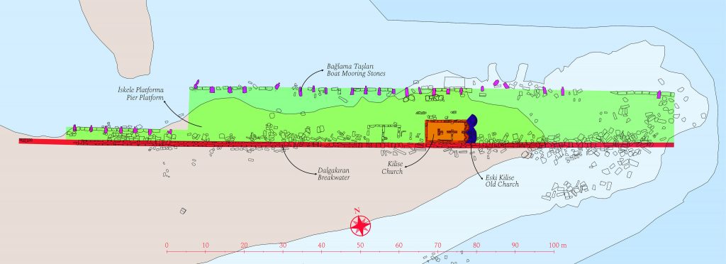
No visible remains have survived to this day from the northern harbor, one of the two known harbors of the city. However, the pier of the southern harbor is one of the best-preserved examples of piers along the Anatolian coast. The semi-worked africano block (Lucullus Marble) unearthed south of the south harbour pier clearly shows that marble blocks were loaded onto ships from the south harbour (portus ante urbem) as well as from the north harbour (portus Geraesticus).Current excavations carried out recently have revealed an east-west aligned breakwater wall, a pier platform adjacent to the breakwater from the north, and the foundation remains of a two-apse church on the pier platform.
The breakwater wall was constructed with large rectangular limestone blocks using a double-faced technique with ties. The cut stone blocks of the wall were fixed to each other with iron clamps which molten lead poured. The structure of the wall was built with a layer of blocks placed as a double wall on the foundation,above it a layer of wide horizontal blocks to connect this double wall layer, and another double-walled layer of blocks on top of this. A cornice block row with an outward protruding profile on both faces crowned the breakwater wall. There are four openings with stairs along the breakwater wall extending. These openings provide access to the pier platform located north of the breakwater.
The paving of the pier platform and the boat mooring stones can still be largely seen on the shore and in the sea today. The wear marks on the stones of the paving indicate that goods were brought to the harbor using wheeled carts. While the pier platform was 5.5 meters wide at the western end, it was widened to 15.4 meters towards the east. The boat mooring stones placed approximately 3.5 meters apart suggest that around 50 boats could be moored to the southern section of the pier.
The architectural blocks on the harbour platform were filled with Roman concrete prepared with dense brick fragments and brick dust. A similar technique can be seen on the inner harbour line, which is almost parallel to the city walls, when proceeding northwards from the breakwater. This line, which is followed 140 m northeast at right angles to the south harbour breakwater and then makes a 28 m turn to the northwest, is thought to be the inner harbour dock line where larger commercial boats docked rather than the small/medium capacity boats moored at the breakwater.
Underwater research conducted at the southern harbor has revealed ballast stones in four clusters southeast of the harbor entrance. The presence of ballast stones around the harbour indicates that the southern harbour was used for commercial purposes. Additionally, the discovery of a skandalopetra, used by traditional sponge divers, east of the cape south of the harbor indicates that sponge diving was also conducted in the area. The sherds of pottery and amphorae are dated to the 6th /7th centuries AD.

Archaeological map of Teos and its surroundings (Kadıoğlu, 2021, 25, Map 4)

